
Alfred the Great’s Fort in Hastings: Where Was It?
SIMON MANSFIELD, a retired Sussex computer programmer interested in the early History of East Sussex, shares his thoughts about the possible location of Alfred the Great’s fort

On the 1066 Walk from Pevensey to Rye by local sculptor Keith Pettit
The Burghal Hidage fort recorded by Alfred the Great at Hastings in 914 AD has never been located, but there is a logical possibility that it could be found on Baldslow Down next to the old Harrow playing fields, near The Ridge.
It would seem that places with dun, don or down in the name imply proximity to old Celtic hill fort locations. Baldslow can be translated from the Anglo-Saxon into Baels – ‘the fire of a funeral pile, in which dead bodies were burned’ and Hleów – ‘A shelter, protection, covering, refuge often applied to persons’. Hence, ‘Baldslow Down’ can be translated as ‘fire refuge hillfort’ – maybe also the origin of ‘Firehills’ at Fairlight.
Harrow Lane, that runs alongside this location, and the Harrow playing fields, can also be derived from the Anglo-Saxon Hár (‘grey-haired with age, old) and Hleóws (A shelter, protection, covering, refuge often applied to persons). Hence, Harrow can be translated into the old refuge.
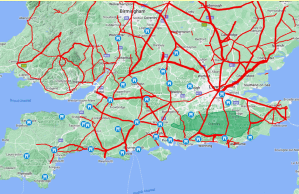
In Roman times, the whole of the Hastings area was an industrial zone. Mining and iron processing took place at Beauport Park, Oaklands and Footlands in Sedlescombe, and Crowhurst Park. A 30ft wide Roman road went from Gravesend through the forest of Andredsweald to Bodiam, where a Roman Port was located, then over the hill at Staplecross, down to Sedlescombe and across the Brede river to Westfield where it appears to have joined another Roman road, from a port in the Brede valley (near the modern Brede bridge up to Baldslow Down). The Romans probably took over an old Celtic hillfort at Baldslow Down in an area where the Celts were processing iron, and this iron may even have been the reason the Romans invaded Britain.
When the Romans left, the Saxons took over, forming an independent Kingdom of the Haestingas, and would have been happy to use an old Roman fort. The majority of the local village names are Saxon, and if Hastings had been settled by the Jutes from Kent it would have been spelt ‘Hastinge’. The Saxons probably took over the hillfort and held it until 771AD when King Offa of Mercia defeated the independent Kingdom of the Haestingas. Finally, after the Battle of Ellendun in 826AD, when Wessex defeated Mercia, Hastings was taken over by Wessex, and was hence included in the Burghal Hidage.

All of Alfred’s Burhs appear to have been on hills, with very good views across the sea. The high point at Baldslow Down gives excellent views across to Romney Marsh and the entrance to the Brede/Rother valleys, which was at Old Romney at the time. This location is also on the old Celtic ridgeway that goes from Fairlight to Crowborough, and was at the end of a Roman road from Gravesend. It has good views towards Telham, where an old Roman castellum (watch tower) would have been located, and also to a second castellum at Castleham, which would overlook the old Hastings harbour in the Filsham valley.
So this location makes a very good observation and defensive position surrounded on all sides by steep hills, and would have made a great position for a Burh, or the site of the capital of the independent Kingdom of the Haestingas.
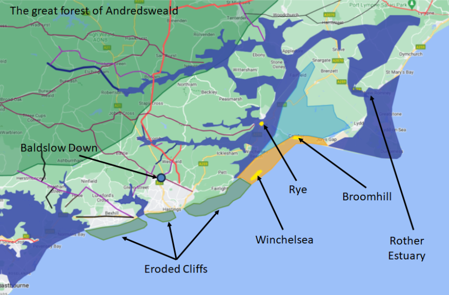
The landscape in the 900s was significantly different from todaythis needs to be explained for a better understanding of the area. To the North of Hastings was the impenetrable Forest of Andredsweald, which only had a few road routes through the Roman Roads and the old Celtic ridgeways. The sea level was at least 3 metres higher, thus providing tidal valleys in the Rother, Brede and Tillingham valleys to the East. The site of Pevensey Marshes would have all been at sea level, at least up to modern Ashburnham. The Eastern Sussex Rother, which now reaches the sea at Rye Harbour, joined the Brede and Tillingham rivers at Appledore. In the 900s it reached the sea at New Romney. The towns of Old Winchelsea and Broomhill would have been on shingle islands that would have been surrounded by tidal salt marsh, and Rye would have been an island that only had access to the sea via Old/New Romney. Finally, the cliffs at Fairlight Cove are currently eroding at about 0.6 metres per year and, 1100 years ago, would have been about 600 metres further into the Channel.
As an aside, a severe storm in 1287AD threw shingle across the Romney Marshes, which blocked the mouth of the Rother at New Romney, which found its current way to the sea via Rye Harbour. This storm also destroyed the old Hastings harbour at Filsham by blocking the valley with shingle from the eroding cliffs at Bexhill, and Hastings moved to the ‘old town’ location.
Please note this article is an educated guess, so if you have any history of Baldslow or Harrow Playing fields, or photos, please let us know, as they may help our investigations.
The map following shows the landscape in approximately 1066AD when Duke William invaded England, and uses Google Maps to show the changes at that time.

SIMON MANSFIELD is a retired Sussex computer programmer interested in the early History of East Sussex. Further details can be found on tinyurl.com/4d26na6f
We hope you have enjoyed reading this article. The future of our volunteer led, non-profit publication would be far more secure with the aid of a small donation. You can also support local journalism by becoming a friend of HIP. It only takes a minute and we would be very grateful.

Leave a Reply