
Interacting with Hastings History
WILL DAVIES, from Whalebone Films, explains how he has developed an interactive Hastings History Map.
When I was young, I had an unusual picture book. It was a series of black and white illustrations of the kind of scenes typically found in children’s books – fun at the seaside, games in the park and so on. But each one had a few characters acting in a strange way – a child who seemed to be staring at something I couldn’t see, a family laughing at nothing… At the bottom of each page was a little plastic slider which, when moved across, revealed another layer of the image, vibrant with colour and wild new additions. The small trees of the original had transformed into large majestic ones with treehouses. I could now see that the child had been staring at a floating nymph which had been hidden before, and the family were laughing at a pair of jesters pulling each other’s noses.
GHOSTS OF CRICKET
That book gave me a similar feeling to that which I get from looking at old photographs of Hastings. Old photos also can reveal a strange layer of reality hiding just out of reach. They can explain some of the anomalies which I’ve noticed around this town. To give just one example, why is there a single old-looking turret next to Priory Meadow Shopping Centre selling burgers and fried-egg baps? Old photos reveal that this turret was once one of a pair which formed the entrance to the Central Cricket Ground – site of county cricket matches, circus performances, political rallies and royal visits – until it was replaced by the shopping centre in the late 1990s. This also explains why the houses on Devonshire Road were built with balconies and large windows – they used to have a view of the pitch, framed by the sea and the castle ruins (now replaced by the tall brick wall of the back of the shopping centre carpark).
When looking at faces in old photographs it can be easy to forget how much time has passed since these images were taken. There’s a woman I notice in one photo with an expression on her face that’s so familiar I’m certain for a fleeting moment that I’ve met her. But then I see she’s sitting in a horse-drawn carriage and holding a parasol, and her dad has a pocket watch. She would have been my great-great grandmother’s generation. Toddlers with grubby grins wearing tatty waistcoats and flat caps. Shopkeepers, pub landladies… inevitably I start wondering what kind of lives these people lived, long ago, in these places that I see everyday. They are simultaneously familar and impossibly distant.
BUILT FOR ANOTHER TIME
In a town like Hastings, old photographs also reveal how much of the built environment remains unchanged. They show how things have become dilapidated (often beautifully so) or parsimoniously adapted to modern life – grand Georgian townhouses with concrete steps bolted on the side as part of a conversion to council flats. The Old Town had its heart ripped out to make way for a main road. Ours is a town that was built for another time and has been clumsily retrofitted. These changes reflect wider developments in the fortunes and aspirations of our society and can be fascinating and occasionally moving.
Old pictures can be like half memories or dreams. I have spent so long looking at photos of the seafront before the changes of the early 20th century that I almost feel I can remember it. Passing by Pelham Cresent and feeling the spray of the waves which came right up to the road back then. Hearing those two bowler-hatted musicians I’ve seen in many photos from the 1890s. Listening in on conversations while sitting in a deckchair in front of the bandstand at Caroline Place (just about where the Carlisle Pub is today).

It’s easy to get sentimental, but it’s important to resist getting lost in the illusions created by old photos. A picture can be worth a thousand words, but by their nature, photographs simplify their subjects.
THE GENTEEL AND THE SHOELESS
Most of my favourite pictures of Hastings date from the time when Robert Tressell was living and working here. The conflicts and injustices he described in the Ragged Trousered Philanthropist were not the subject of thoughtfully composed picture postcards, although if you look carefully, you can catch glimpses of some of the issues he was concerned with. The contrast between the genteel outfits of the wealthy families pictured around the smarter parts of St Leonards and the shoeless children drinking from horse troughs in the Old Town.
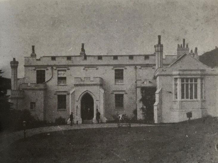
There is one photograph I came across recently while putting together Hastings History Map which offers a window into a complex and significant episode in the history of this town, and even the world. This is an early photo (1860s) of a grand house labelled Halton House. I cycle through Halton most days on the school run and there is no such house there now – rather a few rows of modest terraced houses. What was the story of Halton House? A clue can be found in the name of the road which descends from Halton into the back of the Old Town: Robertsons Hill. Mr P.F. Robertson was the MP for Hastings and resident of the house which was situated near where Hardwicke Road is today, and its stables were where the London Road petrol station now stands.
HASTINGS AND THE OPIUM WARS
Patrick Robertson was a trader and deeply entangled in the illegal import of Indian opium into China’. Huge profits were derived from smuggling illegal substances across borders, and Robertson profited handsomely. In response to the many problems that opium addiction was inflicting on their society, the Chinese authorities tried to further restrict this trade. The British responded with force – an episode known as The Opium Wars. The British decisively won this conflict and, as part of the settlement, the Chinese signed over the Island of Hong Kong. Robertson was well positioned to benefit, and he purchased a large area of seafront there which he developed into a wharf – a move which increased his fortune even more. Now living at Halton House, Robertson spent some of this wealth developing the area of Hastings known as The America Ground where Robertson Street can now be found. He also built Robertson Terrace which forms a beautiful part of the seafront. That fuzzy photograph of the home of its eponymous developer is an invitation to consider the threads of history which converge in those grand facades. (For a full account of all this check out Steve Peak’s book on the America Ground).
SEE FOR YOURSELF
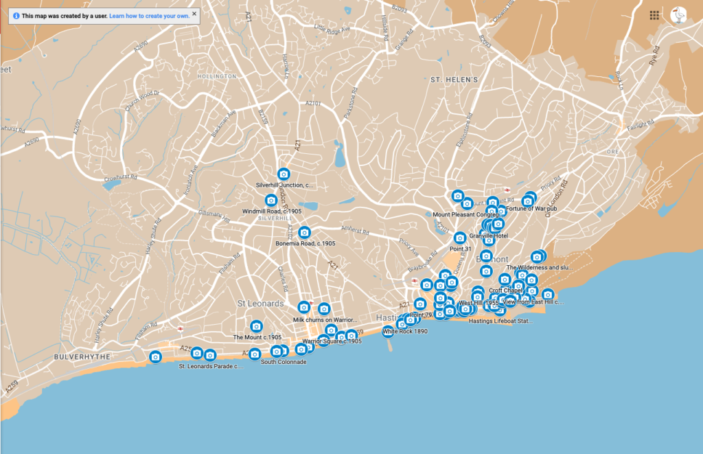
This was my motivation in creating Hastings History Map, which contains over 100 photographs pinned to their actual locations on Google Maps. So, I can stand on a street corner and literally see who stood there over a century ago and wonder about their lives and the world they inhabited. I can see things that were hidden from me before. To wander around town with the History Map for yourself, scan the QR code with your phone’s camera and it will open up on Google Maps.
We hope you have enjoyed reading this article. The future of our volunteer led, non-profit publication would be far more secure with the aid of a small donation. You can also support local journalism by becoming a friend of HIP. It only takes a minute and we would be very grateful.


Thank you so much! Brilliant. No cars, therefore street life.